FAQ
This page includes the questions we are most often asked, by you, the community.
We are committed to bringing you the best possible information and helping you understand emergencies better.
So if there is something you want to know, then let us know, or contact your local emergency services.
Emergency WA FAQs – Emergency WA upgrade and AWS information
EMERGENCY WA FEATURES
What's new?
Natural disasters are unpredictable and can have devastating impacts. Emergency WA’s new personalised emergency planning tool is the best way to keep yourself, your loved ones and your property protected when disaster strikes.
Don’t wait for an emergency to strike to figure out what to do, create your plan today and be prepared for a range of hazards including bushfires, cyclones, floods and storms.
Download the Emergency WA app from the App Store or Google Play. Navigate to My hub to create a watch zone and complete your plan.
On the Emergency WA website, click Plan in the navigation bar and follow the prompts.
The more people who are prepared, the safer and more resilient Western Australian communities will be.
What information is available on this site?
Emergency WA provides:
- Warnings and alerts from a range of government entities. When an incident escalates, a warning or alert may be issued to provide more details and specific safety advice to the community.
- A live feed of incidents reported to DFES which means when a fire or other incident is reported, basic information about the type and location of the hazard will be published. This allows you to find out about a fire or incident as soon as authorities do.
- Earthquake alerts delivered direct to your device. If you have watch zones set up in the Emergency WA app, you’ll receive instant notifications when an earthquake occurs showing location, magnitude and depth.
- Total Fire Bans and Fire Danger Ratings. Check the Fire Danger Rating and Total Fire Bans for your area by selecting the icons in the menu bar, or by visiting Total Fire Bans or Fire Danger Ratings.
- Centres and Closures including a list of evacuation centres that have been opened during an incident, or a park closure that is in place due to a nearby incident
- The ability to choose the information you want to see. By clicking on the Filter menu, you can switch on and off different types of information, including warnings, incidents, Centres and Closures and Natural Hazards.
- A new layers menu to enable you to select different map layers including Local Government boundaries, pastoral areas, DFES regions and Bureau of Meteorology weather layers.
- Easy to access information, in multiple formats. Whether it’s through the interactive, map based layout or in accessible text format you can access the information in the way that suits you. View the text version of warnings and incidents.
- Incident Areas indicate where a fire or other incident has been active. You'll see Incident Areas displayed as grey shapes on the map with the last updated time and date. Incident Areas will always be accompanied by a warning area.
How do I sign up to be notified about alerts and warnings in my area?
Download the app from the App Store or Google Play on your mobile device to receive alerts and warnings relevant to you.
Follow the prompts in the app and create your watch zones. For each watch zone, you can customise the types of notifications you’d like to receive including bushfire warnings, storm warnings, Fire Danger Ratings, Total Fire Bans, prescribed burns, earthquakes and more.
For more information on creating a watch zone, watch the tutorial.
Other ways to be notified:
Emergency Alert is not used in all circumstances. Whether emergency services decide to issue telephone warnings through Emergency Alert will depend on the nature of the incident.
Familiarise yourself with ways to stay informed so you are prepared with a range of information sources during an emergency and remember to check them continuously to stay aware of local conditions.
It is important that you do not rely solely on receiving an official message and should always be aware of what is happening around you, as you could find yourself suddenly in danger. Act decisively the moment you know there is danger.
If you haven’t already done so, create an emergency plan today.
Follow the prompts in the app and create your watch zones. For each watch zone, you can customise the types of notifications you’d like to receive including bushfire warnings, storm warnings, Fire Danger Ratings, Total Fire Bans, prescribed burns, earthquakes and more.
For more information on creating a watch zone, watch the tutorial.
Other ways to be notified:
- Sign up to receive an RSS feed on your device. Visit https://www.emergency.wa.gov.au/#about and select the correct link for your region under RSS and CAP AU feeds menu item.
Emergency Alert is not used in all circumstances. Whether emergency services decide to issue telephone warnings through Emergency Alert will depend on the nature of the incident.
Familiarise yourself with ways to stay informed so you are prepared with a range of information sources during an emergency and remember to check them continuously to stay aware of local conditions.
It is important that you do not rely solely on receiving an official message and should always be aware of what is happening around you, as you could find yourself suddenly in danger. Act decisively the moment you know there is danger.
If you haven’t already done so, create an emergency plan today.
What kind of weather information can I find on Emergency WA?
Emergency WA displays weather information direct from the Bureau of Meteorology including wind direction and speed, rain radar, and cyclone track maps. To turn on weather layers, click the Layers icon.
How do I access Emergency WA warnings data?
Emergency WA data is accessible through the DataWA Shared Location Information Portal, known as SLIP.
This data is provided in multiple formats including machine readable geospatial formats of ArcGIS Map Service, ArcGIS Feature Service, Web Mapping Service and Web Feature Service.
If you have any questions about accessing Emergency WA data, please contact us at statepublicinfo@dfes.wa.gov.au.
This data is provided in multiple formats including machine readable geospatial formats of ArcGIS Map Service, ArcGIS Feature Service, Web Mapping Service and Web Feature Service.
If you have any questions about accessing Emergency WA data, please contact us at statepublicinfo@dfes.wa.gov.au.
UNDERSTANDING EMERGENCY WA
Where does the information on the website come from?
The information on this site comes from a number of sources, including from the State and Federal Governments. This includes details of incidents reported to authorities by members of the public, and alerts and warnings from State Government entities.
What is an Incident?
Emergency WA provides a live feed of active incidents in addition to the alerts and warnings you may be familiar with. This feature provides information about incidents to which DFES is responding.
When an incident is reported to DFES, Emergency WA publishes basic information including the type and location of the incident. You may notice the response type listed in the incident pop-up box which shows how the incident is being responded to. These responses include:
Remember emergencies can happen quickly and there may not always be time to issue a warning before life and property is under threat. It's important to put your plan into action at the first sign of danger. Do not wait and see.
When an incident is reported to DFES, Emergency WA publishes basic information including the type and location of the incident. You may notice the response type listed in the incident pop-up box which shows how the incident is being responded to. These responses include:
- Responding
Resources are mobile and travelling to the incident. - On-Scene
Resources are at the incident. - Monitoring
Resources are monitoring the incident (this can be performed remotely in regional areas).
Remember emergencies can happen quickly and there may not always be time to issue a warning before life and property is under threat. It's important to put your plan into action at the first sign of danger. Do not wait and see.
What is an active alarm?
An Active Alarm incident refers to a Direct Brigade Alarm (DBA). This protected premises fire alarm monitoring network service is provided for all buildings within Western Australia that require a direct data link to a fire brigade.
For more information, visit Direct Brigade Alarm.
For more information, visit Direct Brigade Alarm.
What is a Prescribed Burn?
The Parks and Wildlife Service at the Department of Biodiversity, Conservation and Attractions manage most Prescribed Burns in WA.
Prescribed Burns may be conducted to lower flammable fuel loads to reduce the risk, size and severity of bushfire or for nature conservation.
Active Prescribed Burns will be published on Emergency WA.
More information on Prescribed Burns can be found on the DBCA Parks and Wildlife Service website visit:www.dpaw.wa.gov.au/management/fire/prescribed-burning/burns.
What is a Burn off?
Burn offs can be conducted by Local Governments, State Government agencies, or members of the public.
When the manager of the Burn off reports it to DFES, in line with their permit requirements, it will be published on Emergency WA.
When the manager of the Burn off reports it to DFES, in line with their permit requirements, it will be published on Emergency WA.
What should I do if I am being affected by smoke?
If you see or smell smoke and there isn’t an incident listed on Emergency WA, take immediate action to stay safe and call 000.
If you are impacted by smoke:
If you are impacted by smoke:
- It is recommended you shut doors and windows, and turn off air-conditioners.
- People with asthma and pre-existing respiratory and cardiovascular illnesses should follow their pre-prepared treatment plan.
- If driving through the area, turn on headlights and drive slowly. If you cannot see clearly, pull over to the left, keep your headlights and hazard lights on, and wait until the smoke clears
- If affected by smoke, contact your doctor or call Health Direct on 1800 022 222
- Watch for emergency services personnel and follow their directions
What is a Total Fire Ban?
Total Fire Bans are declared because of extreme weather conditions or when widespread fires are seriously stretching firefighting resources.
When a Total Fire Ban is declared it prohibits the lighting of any fires in the open air and any other activities that may start a fire.
For more information about Total Fire Bans, including what you can and can't do when one is declared, visit the Total Fire Ban page on the DFES website
For current Total Fire Bans visit Total Fire Ban page on Emergency WA
What are Fire Danger Ratings?
Fire Danger Ratings (FDRs) describe the potential level of danger should a bushfire start, based on factors like the weather and the types of vegetation in an area. They are issued daily and provide important information so you can take action to protect yourself and others from the potentially dangerous impacts of a bushfire. The higher the FDR, the more severe a bushfire is expected to be.
For more information about Fire Danger Ratings and what each rating means, visit the Fire Danger Ratings page on the DFES website
For current Fire Danger Ratings visit the Fire Danger Ratings page on Emergency WA
For more information about Fire Danger Ratings and what each rating means, visit the Fire Danger Ratings page on the DFES website
For current Fire Danger Ratings visit the Fire Danger Ratings page on Emergency WA
How can I find Total Fire Bans?
You can find Total Fire Bans by clicking on the Total Fire Ban icon on Emergency WA.
You can also:
You can also:
- View Total Fire Bans on Emergency WA
- Access an RSS feed for Total Fire Bans. on Emergency WA. Select the link under the RSS and CAP AU feeds menu item
How can I find Fire Danger Ratings?
Click on the Fire Danger Rating icon on Emergency WA to see a map of all Western Australian fire weather districts, their associated Fire Danger Ratings and information about what action to take to stay safe.
When Extreme or Catastrophic fire danger ratings are forecast, a notice will appear within the Warnings section on the home page to raise awareness of heightened fire danger.
You can also:
When Extreme or Catastrophic fire danger ratings are forecast, a notice will appear within the Warnings section on the home page to raise awareness of heightened fire danger.
You can also:
- View Fire Danger Ratings on Emergency WA
- Access an RSS feed for Total Fire Bans. on Emergency WA. Select the link under the RSS and CAP AU feeds menu item
What is the Australian Warning System?
The Australian Warning System (AWS) is a nationally consistent approach to warnings for natural hazards including bushfire, flood, storm, cyclone and heatwave.
The latest information about the AWS in Western Australia can be found on the Australian Warning System page.
The latest information about the AWS in Western Australia can be found on the Australian Warning System page.
What is an earthquake alert?
Emergency WA provides instant earthquake alerts detected by Geoscience Australia, the official source for earthquake information.
Earthquake alerts will appear on the Emergency WA app and website giving you access to fast and accurate information such as location, magnitude and depth. If you have watch zones set up and natural hazard alerts switched on, you’ll receive near real-time notifications direct to your device when an earthquake occurs.
You can also submit felt reports through the Geoscience Australia website.
Importantly, if an earthquake is particularly large or causes significant damage, DFES will issue a community warning with all the necessary information to stay safe.
What is a heatwave?
A heatwave occurs when the maximum and the minimum temperatures are unusually hot over a three-day period at a particular location.
I am in a heatwave warning area, what do I do?
Heatwave warnings include the locations affected, the actions you should take to keep safe and other details to help you stay informed during extended periods of high temperatures.
The three warning levels are:
Advice:
A severe heatwave is forecast in the coming days. There is no immediate danger. Stay up to date in case the situation changes.
Watch and Act:
A severe heatwave is occurring. There is a heightened level of threat. Conditions are changing and you need to take action now to protect yourself and your family.
Emergency Warning:
An extreme heatwave is occurring. Heatwave impacts are increasing. You need to take action immediately to protect yourself and your family.
How can I prepare for a heatwave?
For more information on heatwaves and how you can plan ahead for the heat visit Healthy WA.
I am in the power outage alert area, what should I do?
Power outage alerts include details about the locations affected, actions you should take to stay safe and other details to keep you informed during an extended outage.
Further information can be found by visiting Western Power.
Further information can be found by visiting Western Power.
UNDERSTANDING THE EMERGENCY WA APP
How does the Emergency WA app work?
The Emergency WA app is available for download through the App Store or Google Play on your mobile device.
The app is a powerful tool that offers the fastest and most accurate way to receive trusted alerts and warnings for emergencies across Western Australia.
With the app, you’ll have access to:
Emergency WA allows you to stay in the know when it matters most. Learn how to use Emergency WA and the app by watching this video.
The app is a powerful tool that offers the fastest and most accurate way to receive trusted alerts and warnings for emergencies across Western Australia.
With the app, you’ll have access to:
- Trustworthy emergency information with a high-speed notification system
- Interactive maps with live hazard overlays
- The ability to store up to 10 watch zones customised by hazard, severity and location
- ‘Locate me’ function on the map
- Read aloud tool improving accessibility with audio and haptic feedback
- Direct Triple Zero (000) call button from anywhere in the app
- Nation first ‘listen live’ to ABC radio emergency broadcast
- Access to information in offline or low-connectivity areas
- Upload and store critical documents in one place, such as your emergency plan.
Emergency WA allows you to stay in the know when it matters most. Learn how to use Emergency WA and the app by watching this video.
How do I download the Emergency WA app?
You can download the Emergency WA app from the App Store or Google Play.
Once downloaded you can create a login, set your watch zones and start receiving notifications direct to your device about emergencies near you.
Once downloaded you can create a login, set your watch zones and start receiving notifications direct to your device about emergencies near you.
How do I create a watch zone?
You can create up to 10 watch zones in the Emergency WA app.
To create a watch zone, navigate to the My hub tab at the bottom of the screen. Tap on Add a Watch Zone. Accept the Terms and Conditions.
You can set the area by a suburb or an address. If using an address, you can select the radius to be included by using the slider at the bottom of the screen. You can set the area up to 100 kilometres.
Name your watch zone and toggle on/off your preferred notifications for this area. Once complete, select Save watch zone. Your watch zone will now appear in the Watch Zones list in My hub.
How do I delete a watch zone?
You watch zones will be displayed in a list in My hub.
To delete a watch zone, select your named watch zone then in the settings, tap on the three dots icon located in the top right corner of the screen. Tap Delete and confirm you would like to permanently delete your watch zone.
If you would rather pause notifications instead of deleting, you can toggle notifications on/off for one or multiple watch zones from the list.
Note: You can have a maximum of 10 watch zones. If you wish to add a new watch zone, you will be prompted to delete one of your existing watch zones.
What accessibility features are available on the app?
The Emergency WA app features many accessibility features including:
These features can be found in the App settings – Accessibility section on the app.
If you have any feedback about how we could improve the accessibility of Emergency WA, please email: emergencywa@dfes.wa.gov.au.
- a ‘read aloud’ tool included on each warning to read the contents aloud
- text only mode
- audible and haptic feedback and
- map navigation controls.
These features can be found in the App settings – Accessibility section on the app.
If you have any feedback about how we could improve the accessibility of Emergency WA, please email: emergencywa@dfes.wa.gov.au.
How do I use the read aloud tool to listen to warnings?
To play a warning with the read aloud tool, select the speaker icon at the top of the warning. You can pause, rewind or stop the warning as needed.
The read aloud tool uses your device settings for voice and pace. Open your device Settings and select accessibility settings. Here you can adjust the voice, speaking or speech rate and pitch.
The read aloud tool uses your device settings for voice and pace. Open your device Settings and select accessibility settings. Here you can adjust the voice, speaking or speech rate and pitch.
How do I enable location services?
When using the Emergency WA app, you will be prompted to turn on your location by clicking the arrow that appears in the search bar at the top of the map screen. A pop up notification will appear asking if you will allow the Emergency WA app to use your location. Select your preferred option.
Alternatively, open your device Settings and navigate to Apps. Open the Emergency WA app option and select Location or Permissions to enable location services.
Alternatively, open your device Settings and navigate to Apps. Open the Emergency WA app option and select Location or Permissions to enable location services.
How do I share my location?
Select the Share my location button that appears on the right side of the screen. It is the third circle icon from the top of the map screen. If you have not turned on location services, a pop up notification will appear asking to allow the Emergency WA app to use your location. Select your preferred option.
You can then select an option to share your location through the options you have available in your device including via text message, Bluetooth, email and other apps.
You can then select an option to share your location through the options you have available in your device including via text message, Bluetooth, email and other apps.
What type of documents can I save in the app?
You can save documents like your emergency plan, photos and other files in the Documents section of the My Hub tab. The app accepts file formats including PDF, JPEG and PNG.
How do I use the live radio feature in the app?
Select the radio button in the top right corner of the screen. A tab will open with a list of ABC Radio Stations. You can search for a location or select your preferred location from the list, then save.
Once saved, you can click the radio button that appears on all screens within the app and listen to the live stream. You can always change your selection by accessing the radio settings in the app.
Please note, the radio feature only works when you have data connection.
Once saved, you can click the radio button that appears on all screens within the app and listen to the live stream. You can always change your selection by accessing the radio settings in the app.
Please note, the radio feature only works when you have data connection.
CREATING AN EMERGENCY PLAN
What is an emergency plan?
Western Australians face multiple emergencies, sometimes all at once, so it’s important to be prepared and ready to act.
An emergency plan helps you and your loved ones prepare for, respond to, and recover from unpredictable emergencies such as bushfires, cyclones, floods and storms.
To ensure you're prepared, the Emergency WA emergency planning feature includes:
Download the Emergency WA app from the App Store or Google Play. Navigate to My hub to complete your plan.
On the Emergency WA website, click Plan in the navigation bar and follow the prompts.
An emergency plan helps you and your loved ones prepare for, respond to, and recover from unpredictable emergencies such as bushfires, cyclones, floods and storms.
To ensure you're prepared, the Emergency WA emergency planning feature includes:
- Automatic prompts to activate your plan when linked to a watch zone in the Emergency WA app. When hazards occur in your watch zone, you will receive real-time notifications to guide you through your plan.
- Personalised planning tailored to your individual needs, including guidance when preparing your custom emergency kit.
- The ability to share your plan with family and friends.
- Plan activation at any time.
- Ability to create multiple plans for different areas of interest.
- Ability to edit plans created in the app so you can update your plan when circumstances change.
- Offline mode so you can still access your plan in low-connectivity areas without mobile reception.
- Detailed preparedness guides to support learning and readiness.
Download the Emergency WA app from the App Store or Google Play. Navigate to My hub to complete your plan.
On the Emergency WA website, click Plan in the navigation bar and follow the prompts.
Why do I need a plan?
Emergencies can happen without warning and escalate quickly. In these moments, stress, confusion and fear can cloud judgement, making it difficult to think clearly or make fast, effective decisions. When time is critical, indecision can be dangerous, even life-threatening.
Many people underestimate how long it takes to gather essential items, secure their home, evacuate safely or assist vulnerable family members such as children, elderly relatives, or pets. Without an emergency plan, you may forget vital medications, support equipment or important documents.
Creating an emergency plan on Emergency WA will provide you with a clear roadmap to follow when seconds count. Having a plan can help you stay calm, act decisively and ensure everyone knows what to do and where to go.
What hazards does the emergency plan apply to?
An emergency plan helps prepare you, your loved ones and your property for a range of hazards including bushfires, cyclones, floods and storms.
Emergencies are often unpredictable and can escalate quickly, so having a plan in place ensures you’re ready to act when seconds matter. Even if you don’t expect these hazards to hit your home, work or the areas you travel in, being prepared reduces uncertainty and helps guide your decisions during critical moments.
Don’t wait for an emergency to figure out what to do, create an emergency plan on Emergency WA today.
How do I create an emergency plan?
To create an emergency plan, navigate to emergency.wa.gov.au on your web browser and select Plan in the navigation bar at the top of the page. Follow the guided steps to create a plan personalised to your circumstances and ensure you download, share or print a copy for safekeeping. Do not close or quit your browser when creating your plan as your progress will not be saved.
To create an emergency plan on the app, follow these steps:
To create an emergency plan on the app, follow these steps:
- Download the Emergency WA app from the App Store or Google Play.
- Navigate to the My hub tab at the bottom of the screen.
- Select Plans in the navigation bar at the top of the page. Select Create a plan and follow the guided steps to create a plan personalised to your circumstances.
- Ensure the plan is linked to a watch zone and set to Active to receive relevant notifications.
Can I edit an emergency plan?
Once you have created your emergency plan on the Emergency WA website and saved or emailed a copy to your device, you cannot edit it.
You can only edit an emergency plan in the Emergency WA app . Download the Emergency WA app on the Apple Store or Google Play then navigate to My hub and select Plans. Open the plan you want to edit . Scroll to the section you’d like to change and select the pencil icon on the right side of the screen. Here you will have the option to change your answers by working through the questions. Select save changes.
You can only edit an emergency plan in the Emergency WA app . Download the Emergency WA app on the Apple Store or Google Play then navigate to My hub and select Plans. Open the plan you want to edit . Scroll to the section you’d like to change and select the pencil icon on the right side of the screen. Here you will have the option to change your answers by working through the questions. Select save changes.
How can I link an emergency plan to a watch zone?
You can link an emergency plan to a watch zone in the Emergency WA app. Once linked, you will automatically be prompted to use your plan if an emergency occurs within your watch zone.
To link a new emergency plan to a watch zone follow these steps:
To link a new emergency plan to a watch zone follow these steps:
- Navigate to the My hub tab at the bottom of the screen in the Emergency WA app.
- Tap Add a watch zone. Accept the Terms and Conditions.
- Set your watch zone area by a suburb or an address. Name your watch zone and toggle on/off preferred notifications. Save watch zone.
- Select Plans in the navigation bar at the top of the My hub tab. Select Create a plan, name your plan.
- When asked Where is your emergency plan for? Select An existing watch zone. From the drop-down menu select your desired watch zone.
- Complete plan. Ensure your plan is set to Active and your watch zone is enabled to receive desired notifications.
- Navigate to the My hub tab at the bottom of the screen in the Emergency WA app.
- Select Plans from the navigation bar. Open the desired plan. Scroll down the page to Name and Location. Press the edit icon.
- Here you will have the option to rename your plan. Select Next. When asked Where is your emergency plan for? Select an existing watch zone. From the drop-down menu select your desired watch zone.
- Complete plan. Ensure plan is set to Active and your watch zone is enabled to receive desired notifications.
Can I create more than one plan?
A single emergency plan will help prepare you for a number of hazards including bushfires, cyclones, floods and storms.
On the Emergency WA website you can create and download as many plans as you’d like for different areas of interest like your home, work or travel destination.
On the app, you can create up to 10 emergency plans. Each plan can be linked to a watch zone to receive personalised, near real-time notifications direct to your device alerting you when an incident occurs. You can not attach multiple plans to the same watch zone.
How can I use an emergency plan?
Once you’ve completed your emergency plan, you should download, email or print a copy and save it in a designated, easily accessible place that all household members know about. It’s important to ensure your plan is available offline as mobile networks can fail during emergencies.
If you created your plan on the Emergency WA app, you can manually use your plan by navigating to My hub and selecting Plans. Select Use plan. If there is no active warning in the watch zone attached to the plan, you’ll be asked to select the emergency type you want to use your plan for.
If you created your plan on the Emergency WA app, you can manually use your plan by navigating to My hub and selecting Plans. Select Use plan. If there is no active warning in the watch zone attached to the plan, you’ll be asked to select the emergency type you want to use your plan for.
Why has the Emergency WA app prompted me to use my emergency plan?
If you have linked an emergency plan to a watch zone, the Emergency WA app will automatically prompt you to use your plan when disaster strikes. This world-leading capability helps cut out indecision when seconds matter. The app will guide you through your emergency plan, delivering your decisions back to you.
To access this feature, you must have your Plan status set to Active.
To access this feature, you must have your Plan status set to Active.
Can I pause app notifications for an emergency plan?
You can only receive notifications on the Emergency WA app. To pause notifications for an emergency plan, navigate to My hub and select Plans. Open the plan you’d like to pause. Select the drop-down menu next to Plan status, and change your plan from Active to Paused.
When your plan is paused you will not receive any notifications for the plan. If your plan is linked to a watch zone that is still active, you will continue to receive notifications for the watch zone.
If an emergency strikes and you need to use your plan, you can manually activate it by navigating to My hub, Plans and selecting Use plan. You will be prompted to select the type of emergency you are using your plan for.
Why am I getting an error when entering my phone number in Who will you contact section?
If you’re adding a landline number in the “Who will you contact” section of the plan, you must include 08 at the start of the number to activate the Save button. E.g. 08 9395 9300 instead of 9395 9300. Mobile numbers will automatically add +61.
Why was My Bushfire Plan replaced?
Emergency planning is not just about bushfires. The emergency plan within Emergency WA empowers you to prepare for a range of hazards including bushfires, cyclones, floods and storms. By linking your plan to a watch zone in the Emergency WA app, you will receive instant notifications when an emergency occurs. You’ll be guided through critical actions such as contacting loved ones, packing an emergency kit and relocating safely, cutting out indecision when it matters most.
DURING AN EMERGENCY
Who is in charge of emergencies in WA?
Preparing for and responding to emergencies is a shared responsibility between the Government, community and individuals. Getting prepared for emergencies is one of the best ways that you can get involved.
For more information about the management of emergencies in Western Australia refer to the State Emergency Management Committee at https://www.wa.gov.au/organisation/state-emergency-management-committee
For more information about the management of emergencies in Western Australia refer to the State Emergency Management Committee at https://www.wa.gov.au/organisation/state-emergency-management-committee
Why didn't someone let me know there was an emergency near me?
Emergencies can strike at any moment, and there may not always be enough time to issue a warning before life or property is under threat.
It is important to seek information from a variety of sources and be prepared to take action to keep yourself safe. If in any doubt, take action straight away.
Find out more ways to find emergency information
It is important to seek information from a variety of sources and be prepared to take action to keep yourself safe. If in any doubt, take action straight away.
Find out more ways to find emergency information
Who will protect me during an emergency?
It is your responsibility to take action during an emergency. Stay aware of your surroundings and follow advice from emergency services.
Emergencies can happen anywhere, any time. Prepare yourself and your property for emergencies. If you are travelling through high-risk areas, be prepared and ready to act.
To ensure you are prepared for an emergency visit www.emergency.wa.gov.au/prepare
Emergencies can happen anywhere, any time. Prepare yourself and your property for emergencies. If you are travelling through high-risk areas, be prepared and ready to act.
To ensure you are prepared for an emergency visit www.emergency.wa.gov.au/prepare
What should I do with my pets?
It is your responsibility to prepare for the safety and welfare of your pets and farm animals during an emergency. It is a good idea to have a pet emergency kit and survival plan for your animals to help guide your actions during an emergency
Check with your local shire if there are animal welfare arrangements in place.
It is important to note that most evacuation centres are not able to accept animals. You may need to make alternative arrangements with family and friends who live away from the area.
For more information visit the DFES Animals and Emergencies page on the DFES website.
You can also find information on Animal welfare during bushfires on the Department of Primary Industries and Regional Development website.
I am concerned about family members/friends who may be impacted by an emergency - who can I contact?
Try to contact them directly or indirectly through friends, neighbours, or colleagues. If you have serious concerns for someone's safety and welfare, call WA Police.
During major incidents the Red Cross may set up the Register.Find.Reunite hotline. Information about the hotline will be included in the relevant warnings on Emergency WA
During major incidents the Red Cross may set up the Register.Find.Reunite hotline. Information about the hotline will be included in the relevant warnings on Emergency WA
My home is in the affected area and I'm not there. How do I know if my property is okay? When can I return?
It is understandable that you may be anxious to find out what's happening.
The first priority of emergency responders is to protect life and property at the scene of the incident, so it's important to be patient and let them do their jobs.
They will be doing all they can to reduce the risk to your property and the people in the area.
During an emergency, even after the immediate threat has passed, there will be other hazards such as burnt or fallen trees, loose debris and damage to roads and infrastructure.
Residents will be allowed to return once the agencies in charge are confident the area is safe.
Let your family and friends know you are safe in the meantime, as they may be looking for you.
How can I help during an emergency?
Generally, donations of food or goods are not necessary and cannot be stored or distributed during the emergency response
During major emergencies the Lord Mayor's Distress Relief Fund may be activated to coordinate financial donations. More information is available at www.appealswa.org.au
During major emergencies the Lord Mayor's Distress Relief Fund may be activated to coordinate financial donations. More information is available at www.appealswa.org.au
TROUBLESHOOTING
Which internet browser works best with Emergency WA?
Emergency WA works best on the latest versions of Google Chrome, Apple Safari and Microsoft Edge. For the best user experience, ensure you are using the latest version of one of these browsers.
The Emergency WA map is wrong?
The map on Emergency WA is provided by Mapbox. If you notice a map error, please visit the Mapbox website and report the issue
I can see an incident but it isn't appearing on your website at all - what should I do?
First, make sure you are not in any immediate danger. Act for your own safety and move to a safer location if necessary.
Call 000 to report the incident to the relevant authority.
Call 000 to report the incident to the relevant authority.
The information listed for an emergency is inaccurate - what should I do?
If the error is an incorrect place name, road closure information or other inaccuracy in the information provided, then please contact the agency that has issued the warning to let them know. The name of this agency will appear within the warning.
Who can I contact for Emergency WA app support?
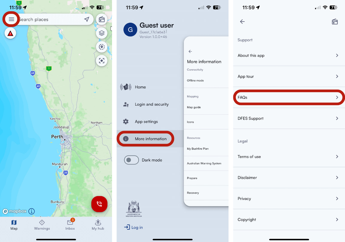
An app tour and FAQs are available on the app, which can be found under ‘More information’ from the menu screen.
Tutorial videos are also available:
Should you need additional help, you can email emergencywa@dfes.wa.gov.au. Please note this inbox is monitored during business hours only and should not be used for emergency purposes.
Tutorial videos are also available:
Should you need additional help, you can email emergencywa@dfes.wa.gov.au. Please note this inbox is monitored during business hours only and should not be used for emergency purposes.
Why am I not receiving any notifications from the Emergency WA app?
You may not receive notifications for several reasons. Below are some tips to help ensure you receive information from Emergency WA:
- The incident or warning alert is outside of your watch zone’s boundary. You may wish to adjust the size of your watch zone or create an additional watch zone to capture a greater area.
- Check that notifications for information you’d like to receive are turned on (for example: Incidents or Total Fire Bans).
- Check that you haven’t logged out of the app.
- Ensure push notifications are enabled in your phone settings. To turn on notifications, navigate to Settings in your phone, followed by Notifications, then select Emergency WA. Here, you will be able to turn on notifications and choose how notifications will appear on your phone.
- You will not receive notifications if your device is in Do Not Disturb mode, Battery Saver mode or Background App Refresh is disabled for the app. Check these settings in your phone and consider adjusting them to ensure you receive notifications.
What devices does the Emergency WA app support?
The emergency WA app is available for Apple smartphones and devices operating Android.
- For Apple iPhones, Emergency WA is supported on iOS Versions 14 and above.
- For Android devices, Emergency WA is supported on version 7 and above.
- The app also works on tablets.
FEEDBACK
Got another question? Let us know.
You can email us at:
emergencywa@dfes.wa.gov.au
Please note this inbox is monitored during business hours only and should not be used for emergency purposes. Due to the volume of enquiries received we can't respond to each one. However, your feedback is important to us and will help us to plan future improvements to Emergency WA
To report a life threatening emergency, please call 000. For information about a current incident, please check the warnings page or call 13 DFES.